


The legacy of Banda Singh Bahadur's cis-Sutlej conquests
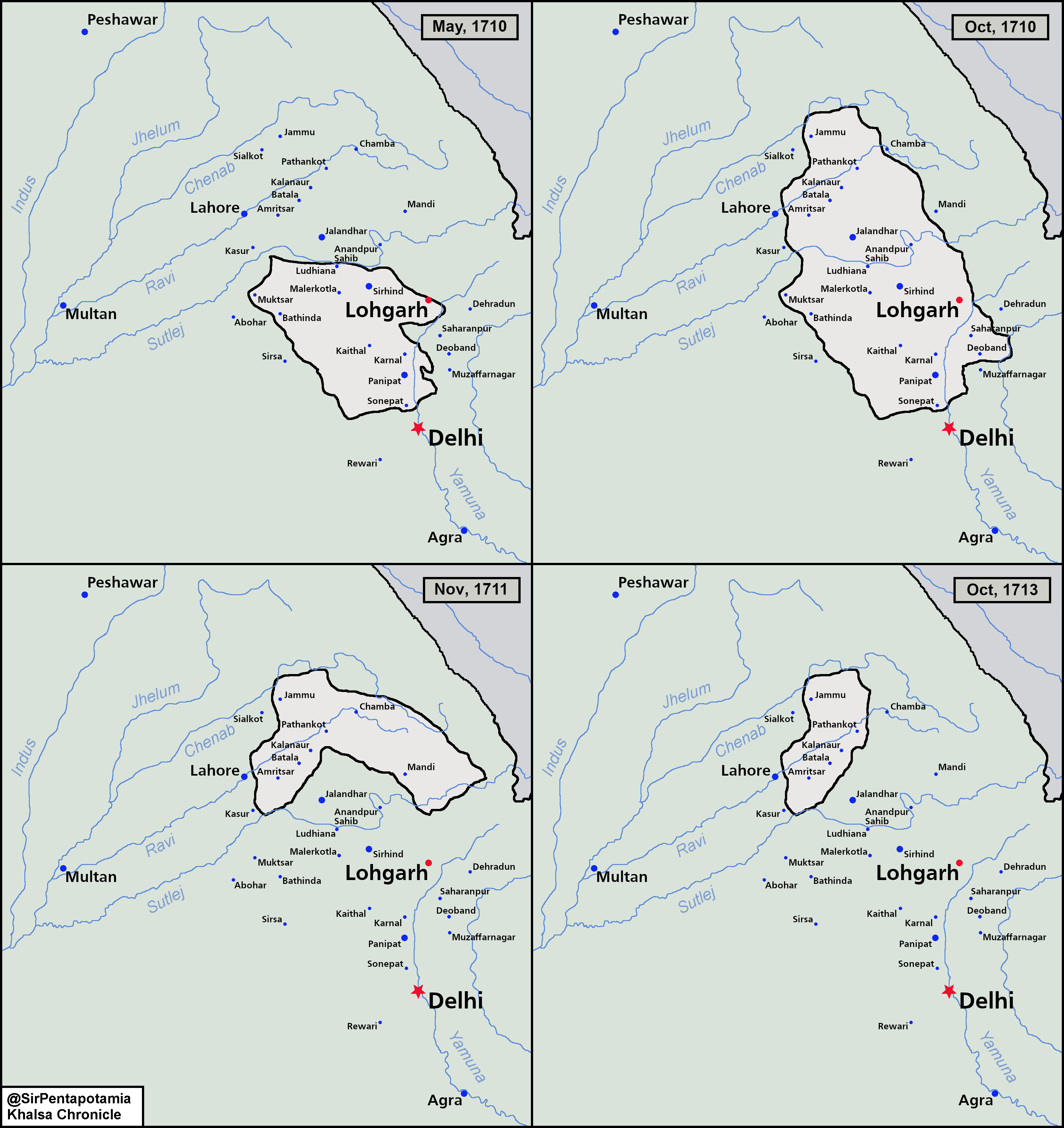
A visualisation of Banda Singh Bahadur's influence in Punjab, Pahadi areas, Bagar tracts and the Upper Doab

History behind Banda Singh’s conquests
Banda Singh’s initial conquest began in the Malwa, Upper Doab and Puadh regions. The Battle of Sonipat is widely regarded by historians to be the first recognised battle of Banda Singh Bahadur against the Mughals. From Sonipat, Banda Singh moved northwards to Samana, Sirhind and Sadhaura and took over all the key cities of the Sirhind sarkar.
Slowly, the whole of Sirhind sarkar fell under Banda Singh’s rule, alongside various parts of the Hissar Firuza and Delhi sarkar. Ganda Singh notes: “Banda Singh was, in a few days, the undisputed master of the territory of Sadhaura to Rai Kot, and from Machhiwara and Ludhiana to Karnal” - marking his rule over the Sirhind sarkar. After Banda Singh had appointed governors in the Puadh and Malwa region, he headed towards the Upper Doab region. Banda Singh had conquered Saharanpur, Nanauta and the Jalalabad countryside but was unable to take the fort of Jalalabad, around 40 kilometres away from Saharanpur.
As many historians note, it is quite difficult to understand clearly the chronology of battles that occurred. Meanwhile, Banda Singh was conquering the Malwa, Upper Doab and Puadh regions, the Majha and Doaba regions were being conquered by his Panj Pyare appointees. In Doaba, the fort of Rahon had been sieged and Jalandhar and Hoshiarpur were now being administrated under the Sikhs. Meanwhile, in Majha, the contingents had split amongst themselves; one of the contingents went to siege the fort of Lahore meanwhile the other gone to siege Batala, Kalanaur and Pathankot. Although, the Majhail Sikhs’ army won a few engagements near Bhilowal, they did not succeed in taking over Lahore proper. However, the other contingent had successfully taken over the market towns of Batala, Kalanaur and Pathankot. This was the territorial peak of Banda Singh’s empire.

From then on, Bahadur Shah reconquered parts of Malwa and the Upper Doab. He entered Sonepat in late October, 1710, which was at the southern tip of Banda Singh’s holdings. Meanwhile, the Sikhs in Sonipat retreated towards Lohgarh as Bahadur Shah’s forces reached Sadhaura. Both Sadhaura and Lohgarh were eventually taken over so Banda Singh retreated towards the northern part of his realm and began to take on the hill chiefs of Himachal: Mandi and Bilaspur had accepted overlordship and relations with Chamba were normalised. In 1711, Banda Singh reconquered Gurdaspur and looted Kalanaur and Batala. Bahadur Shah’s health was failing and eventually passed away in late February. Meanwhile, Banda Singh retook territory until Sadhaura in early February. Until February 1713, the Mughals were involved in a bitter succession crisis between Jahandar Shah and Farrukh Siyar. Eventually, Jahandar Shah retook Sadhaura in late June, 1713. Banda Singh administrated his holdings from Jammu for 2 years until early March, 1715, when he conquered Batala and Kalanaur for a third time. He held out for six months until his capital of Gurdas Nangal was retaken in late December, 1715.
Legacy
In order to create the maps, a finer knowledge of the Mughal administrative boundaries was needed. Irfan Habib’s Atlas of the Mughal Empire allows us to get a better look at the subahs, sarkars and parganas of the empire around 1707. Quotes from Mughal chronicles give us a general idea of the territory that Banda Singh controlled, alongside secondary sources like Ganda Singh’s Life of Banda Singh Bahadur and Harbans Kaur Sagoo’s Banda Singh Bahadur and Sikh Sovereignty.
Banda Singh’s rebellion was centred around the Lahore and Delhi subahs, among the most important subas of the Mughals, at the heart of the empire. Many of the towns conquered by Banda Singh were incredibly important to Mughal Punjab, Kalanaur was the town where Mughal emperor Akbar was coronated meanwhile Sirhind was the seat of the Islamic scholar Ahmad Sirhindi. There was large-scale wealth transfer from these quintessential Mughal towns like Rahon, Kalanaur and Sunam to cities set up by Sikhs like Kapurthala, Gurdaspur and Patiala, helping to create Sikh hegemony in Punjab for future generations.

As with all historic maps, it is quite difficult to get borders accurate to exactly represent real life borders, especially with Banda Singh’s conquests and Mughal reconquests as they took place in such quick succession. However, the aforementioned literature allowed us to create an accurate estimate on how the borders of Banda Singh’s conquests appeared, so we can create the maps. These allow us to get a better visual representation of Banda Singh’s influence upon Punjab and the Gangetic plains. His influence inevitably led to the creation of the Sikh misls. Conclusively, his territorial ambitions can be reflected with Sikh demographics today, with the absolute majority of controlled territory is in present day India. In the peak of Banda Singh’s rule, he held power from Jammu to Sonipat; all areas where significant Sikh minorities still exist to this day.

Thank you for this very helpful visualisation. Mapping out the battle and conquests really brings out how geostrategically planned out the campaigns were. In my view, the planning for these campaigns might have gone on for a while, possibly even beginning in Nanded. In terms of cartographic representation, it would be interesting to juxtapose this with a satellite map. These Sikh campaigns were so devastating for the Mughal empire for multiple reasons : one that the region conquered by the Khalsa Army was all plains territory wedged between the Rajputana deserts and the Himalayas. It cut off north central India from the Silk Road economy, in addition to land tax revenues, and also perhaps more importantly the mercenary markets of Central Asia. An interesting historical correlation is that the East India Company’s trading rights, which had revoked by Aurangzeb after a brief war (Child’s War), were reinstated by Farrukhaiyyar after the shock of the Sikh campaigns. No doubt the loss of northern land and trade revenues was a factor.
Thank you once again. Hope for more soon.
Please can you do the same for the entire misl period? Starting right from 1716 all the way to the establishment of Sikh Empire